Cycling
Le col du Pourtalet en VAE
Contact
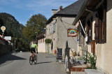
LARUNS
- Distance :
- 27.5 km
- Vertical rise :
- Dénivelé positif cumulé 1300
- Temps de parcours :
- 2h
- Level of difficulty :
- Moyenne
- Mode of travel :
- à VAE
Presentation
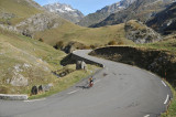
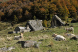
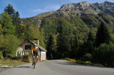
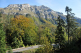
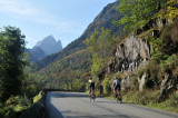
A border crossing between the Ossau valley and Spain, the Col du Pourtalet is reached by a fairly long but never steep route, crossing a wide variety of landscapes. As well as being a physical challenge, albeit mitigated by the use of electric assistance, climbing it by bike also allows you to immerse yourself in the heritage and historical dimension of the route. A communication route since the dawn of time, the Pourtalet route has seen the passage of merchants and peddlers, smugglers and pilgrims. Every year, the Gabas valley also plays host to the lively transhumance of flocks and herds to the bountiful summer pastures of the Pic du Midi d'Ossau. If, on leaving Laruns, the road boldly defies the Hourat gorges, it then makes a long, easy approach between the Gave and the boxwoods, passing through the Eaux-Chaudes spa and the cheese-salting village of Gabas.
Details
- Type of route :
- VAE
Download
Itinéraire
 Departure/Arrival
 Point of interest

De Laruns à Gabas

De Gabas à Pont de Camps

De Pont de Camps au Pourtalet
Pics
Pics