De Gabas à Gourette variante

Contact
LARUNS
mail / message
FICHE_INFO_SIMPLE_ECRIRE_MESSAGE
Fields with an asterisk * must not be left blank
My request
Your Contact Details
In accordance with Law No. 78-17 of 6 January 1978 of the National Committee for Information Technology and Civil Liberties (CNIL) with regard to computing, files and liberties (article 36), the interested party is entitled to ask for his/her personal information to be rectified, completed, clarified, updated or deleted if it is inaccurate, incomplete, ambiguous, elapsed or in respect of which it is forbidden to use, disseminate or store said information. Should you wish to exercise this right, please specify the fact in the form above.
  • Distance :
    • 30 km
  • Vertical rise :
    • Dénivelé positif cumulé 2200
  • Temps de parcours :
    • 9h
  • Level of difficulty :
    • Difficile
  • Mode of travel :
    • à pied

Presentation

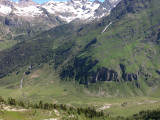
If at the end of spring, some passages on the GR 10 pose snow problems and require special equipment (crampons, ice axe) that you don't have, then don't hesitate and take this variant between Gabas and Gourette!
Array
    Details
    • Type of route :
      • Pédestre
    Itinéraire

    Map

    - Departure/Arrival
    - Point of interest
    • Chapelle Gabas

    Pont des Athas

    Falaise de la Tume

    Falaise de la Tume - Cabane de Laga de Haut

    Cabane de Laga de Haut - Eaux-Bonnes

    Eaux-Bonnes - Gourette

    Pics

    Pics

    • Iti-Gabas-Gourette2-CDT64
    • Soussoueou1
    • Iti-Gabas-Gourette1©CDT64
    • Gourette-ete1-©OTGourette-Jantou
    Iti-Gabas-Gourette2-CDT64Soussoueou1Iti-Gabas-Gourette1©CDT64Gourette-ete1-©OTGourette-Jantou